Chang'e 3 Lander and Rover From Above
http://lroc.sese.asu.edu/news/in ... ver-From-Above.html
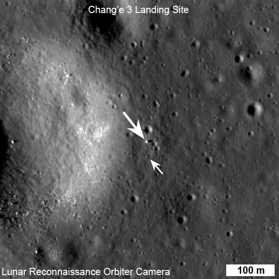
LROC NAC view of the Chang'e 3 lander (large arrow) and rover (small arrow) just before sunset on their first day of lunar exploration. LROC NAC M1142582775R, image width 576 m, north is up [NASA/GSFC/Arizona State University].
Chang'e 3 landed on Mare Imbrium (Sea of Rains) just east of a 450 m diameter impact crater on 14 December 2013. Soon after landing, a small rover named Yutu (or Jade Rabbit in English) was deployed and took its first tentative drive onto the airless regolith. At the time of the landing LRO's orbit was far from the landing site so images of the landing were not possible. Ten days later on 24 December, LRO approached the landing site, and LROC was able to acquire a series of six LROC Narrow Angle Camera (NAC) image pairs during the next 36 hours (19 orbits). The highest resolution image was possible when LRO was nearly overhead on 25 December 03:52:49 UT (24 December 22:52:49 EST). At this time LRO was at an altitude of ~150 km above the site, and the pixel size was 150 cm.

LROC NAC before and after images of the Chang'e 3 landing site [NASA/GSFC/Arizona State University].
The rover is only about 150 cm wide, yet it shows up in the NAC images for two reasons: the solar panels are very effective at reflecting light so the rover shows up as two bright pixels, and the Sun is setting thus the rover casts a distinct shadow (as does the lander). Since the rover is close to the size of a pixel, how can we be sure we are seeing the rover and not a comparably sized boulder? Fortuitously, the NAC acquired a "before" image (M1127248516R) of the landing site, with nearly identical lighting, on 30 June 2013. By comparing the before and after landing site images, the LROC team confirmed the position of the lander and rover, and derived accurate map coordinates for the lander (44.1214°N, 340.4884°E, -2640 meters elevation).

Chang'e 3 lander panorama [Images from CNSA; compiled by Di Lorenzo and Kremer] showing Yutu shortly after it drove down the ramp to the surface. Yellow lines connect craters seen in the panorama and the LROC image (taken at a later date after the rover had moved), red lines indicate approximate field of view of the panorama.
The lander set down about 60 meters east of the rim of a 450 meter diameter impact crater (40 meters deep) on a thick deposit of volcanic materials. A large scale wrinkle ridge (~100 km long, 10 km wide) cuts across the area and was formed as tectonic stress caused the volcanic layers to buckle and break along faults. Wrinkle ridges are common on the Moon, Mercury and Mars.
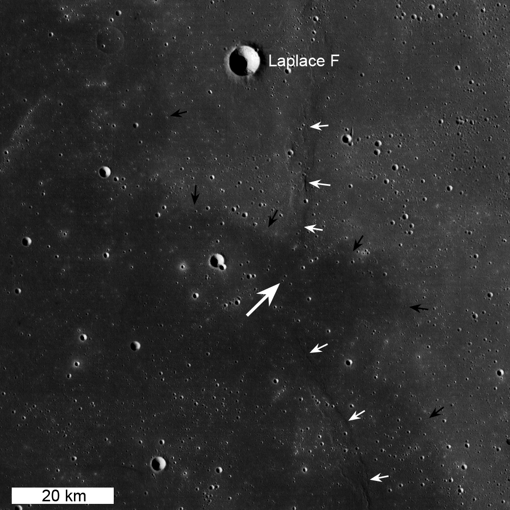
LROC WAC context mosaic for the Chang'e 3 landing site (large white arrow); small white arrows indicate wrinkle ridge and small black arrows delimit boundary between "red" mare (northeast) and "blue" mare (southwest), image is 100 km wide [NASA/GSFC/Arizona State University].
Lunar mare basalts are divided into two main spectral (color) types: "red" and "blue" (blue is perhaps a misnomer, think "less red"). Basalts on the Moon (same on Earth) are composed mainly of two minerals, pyroxene and plagioclase, though olivine and ilmenite can sometimes occur in significant amounts. The presence of ilmenite (FeTiO3) results in lower reflectance and a "less-red" color - thus the blue basalts. The landing site is on a blue mare (higher titanium) thought to be about 3.0 billion years old. The boundary (black arrows in above WAC mosaic) with an older (3.5 billion years) red mare is only 10 km to the north.

LROC WAC color (689 nm, 415 nm, 321 nm) overlain on WAC sunset BW image. Note the proximity of the landing site to a contact between red and blue maria [NASA/GSFC/Arizona State University].
A large area LROC WAC topography map of the Imbrium basin and surrounds is available here. |


 发表于 2013-12-16 10:50:26
 提升卡
提升卡 置顶卡
置顶卡 变色卡
变色卡 楼主
楼主